Ceilândia | |
|---|---|
| Região Administrativa de Ceilândia Administrative Region of Ceilândia | |
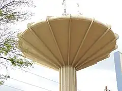
Clockwise from top: City view, Water Tower, Bus terminal, Casa do Cantador, Fair, Ceilândia sign | |
 Flag | |
| Nickname: Cei | |
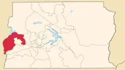
 Localization of Ceilândia in Federal District | |
 Ceilândia Localization of Ceilândia in Brazil | |
| Coordinates: 15°49′09″S 48°06′30″W / 15.81917°S 48.10833°W | |
| Country | |
| Region | Central-West |
| State | |
| Founded | March 27, 1971 |
| Government | |
| • Regional administrator | Vilson José de Oliveira[1] |
| Area | |
| • Total | 230.30 km2 (88.92 sq mi) |
| Elevation | 1,000 m (3,000 ft) |
| Population (2010)[2] | |
| • Total | 398,374 |
| • Density | 1,729.8/km2 (4,480/sq mi) |
| Demonym | Ceilandense |
| Time zone | UTC−3 (BRT) |
| Postal Code (CEP) | 72200-000 |
| Area code | +55 61 |
| Website | www.ceilandia.df.gov.br |
Ceilândia (Portuguese pronunciation: [seiˈlɐn.dʒiɐ]) is an administrative region in the Federal District in Brazil. It is bordered by Brazlândia to the north, Taguatinga to the east, and Samambaia and Sol Nascente/Por do Sol to the south. With about 398,374 inhabitants, it is the administrative region of largest population in the Federal District.[3] Ceilândia was created as a city on 27 March 1971 by Hélio Prates da Silveira,[4] originally created as the "CEI" (Portuguese: Campanha de Erradicação de Invasões, lit. 'Invasions Eradication Campaign') in 1969, a campaign to combat irregular settlements near Brasília.
History
Early history
Ceilândia was originally created by the government in the 1970s as a campaign by then governor Hélio Prates da Silveira to keep people from moving into Brasília and setting up invasions.[5] The root of the name Ceilândia is "CEI" (Portuguese: Campanha de Erradicação de Invasões: Invasions Eradication Campaign).[6] The campaign was created by Hélio Prates da Silveira to prevent people from invading Brasilia, and to combat irregular settlements in the region.[7]
In 1969, after only nine years of existence, Brasília already had 79,128 people living in irregular occupations, out of a population of 500 thousand inhabitants in all the Federal District. In that year a seminar took place in Brasília concerning social problems of the Federal District. Invasion dwellers were the most serious problem.
17619 lots were laid out and in 1970 the first construction began. In nine months the transfer of the families was concluded with the streets opening. The population had no water, no public lighting, no public transport and struggled against dust, mud and flash floods.
Recent developments
Today Ceilândia is the largest electoral college of the Federal District and the most populous city, with more inhabitants than the Brasília. It occupies a total of 91 residential squares laid out like Brasília, intercalated by areas for local commerce, churches and schools. There are also some special areas that are set aside to provide community services.

An active commercial center, it has 4,500 commercial establishments and 1,600 small industries. The economically active population is more than 160,000 people.
Two important locals of Ceilandia are the Caixa d'Água (Water Tower), and the Casa do Cantador (House of the Singer), a cultural center dedicated to the artists of Northeast Brazil.[8] The building was designed by Oscar Niemeyer and completed in 1986.
Ceilândia and its fairs
Ceilândia is considered the second largest "Northeastern city" outside the Brazilian Northeast Region (the first one is São Paulo).[9] About 70% of the population is of Northeastern origin.[10] The presence of the Northeast culture can be seen in the number of open-air fairs (13 in all). The fairs (feiras-livres) are also an alternative for the workers that did not find space in the economy of the Federal District. In most of them, fruits, foods, clothes and footwear are commercialized. The Fair of the Producer (Feira do Produtor e Atacadista de Ceilândia) sells wholesale and supplies almost 50% of the Federal District.
The Central Fair (Feira Permanente de Ceilândia), is the largest of all. It occupies an area of seven thousand square meters and sells household articles, tools, electric appliances, fruits, vegetables, and poultry. It is located next to the Caixa d'Água (Water Tower) - the symbol of Ceilândia. Another fair is the Feira do Rolo.
Sports
Venues
- Estádio Maria de Lourdes Abadia
Clubs
- Football
Transportation
Ceilândia is served by several highways connecting it to Brasília
- DF-075 (Estrada Parque Núcleo Bandeirante - EPNB);
- DF-085 (Estrada Parque Taguatinga - EPTG, or "Linha Verde");
- DF-095 (Estrada Parque Ceilândia - EPCL, or "Via Estrutural").
Metro
Ceilândia is served by the following Federal District Metro stations:
See also
References
- ↑ "Perfil do administrador" (in Portuguese). Administração Regional de Ceilândia, DF. Retrieved 2015-01-01.
- ↑ "Pesquisa Distrital por Amostra de Domicílios - 2010/2011" (PDF) (in Portuguese). Codeplan. Archived from the original (PDF) on 2012-02-17. Retrieved 2012-08-20.
- ↑ Patriolino', 'Luana (2021-03-27). "Cidade mais populosa do DF, Ceilândia chega aos 50 anos com economia própria". Cidades DF (in Brazilian Portuguese). Retrieved 2023-06-12.
- ↑ "Ceilândia: 41 anos de história, tradição e modernidade!". www.unodc.org. Retrieved 2023-06-12.
- ↑ PODER360 (2021-03-27). "Ceilândia, implantada no apartheid de Brasília, completa 50 anos". Poder360 (in Brazilian Portuguese). Retrieved 2023-06-12.
{{cite web}}: CS1 maint: numeric names: authors list (link) - ↑ Brasília, Histórias de (2020-03-27). "A origem de Ceilândia". Histórias de Brasília (in Brazilian Portuguese). Retrieved 2023-06-12.
- ↑ Brasília, Histórias de (2020-03-27). "A origem de Ceilândia". Histórias de Brasília (in Brazilian Portuguese). Retrieved 2024-01-04.
- ↑ "História de Ceilândia se mistura com o Nordeste". Acervo (in Brazilian Portuguese). 2018-03-27. Retrieved 2024-01-04.
- ↑ Ribeiro, Raquel Martins (2018-09-09). "Sabores e ritmos de Ceilândia: o reduto nordestino da capital federal | Metrópoles". www.metropoles.com (in Brazilian Portuguese). Retrieved 2024-01-04.
- ↑ Flávio, Lúcio (2020-01-05). "Ceilândia ganha título de Capital da Cultura Nordestina no DF". Agência Brasília. Retrieved 2023-01-04.


.jpg.webp)

