Campénéac
Kempenieg | |
|---|---|
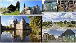
 Clockwise from upper left: old lavoir; Church of Our Lady; mural of Paimpont forest; carved demon supporting the church pulpit; street views of the commune; Château de Trécesson | |
.svg.png.webp) Coat of arms | |
Location of Campénéac | |
 Campénéac  Campénéac | |
| Coordinates: 47°57′30″N 2°17′36″W / 47.9583°N 2.2933°W | |
| Country | France |
| Region | Brittany |
| Department | Morbihan |
| Arrondissement | Pontivy |
| Canton | Ploërmel |
| Intercommunality | Ploërmel |
| Government | |
| • Mayor (2020–2026) | Hania Renaudie[1] |
| Area 1 | 60.57 km2 (23.39 sq mi) |
| Population | 1,891 |
| • Density | 31/km2 (81/sq mi) |
| Time zone | UTC+01:00 (CET) |
| • Summer (DST) | UTC+02:00 (CEST) |
| INSEE/Postal code | 56032 /56800 |
| Elevation | 46–216 m (151–709 ft) |
| 1 French Land Register data, which excludes lakes, ponds, glaciers > 1 km2 (0.386 sq mi or 247 acres) and river estuaries. | |
Campénéac (French pronunciation: [kɑ̃peneak]; Breton: Kempenieg) is a commune in the Morbihan department of Brittany in north-western France.[3] Inhabitants of Campénéac are called in French Campénéacois.
References
- ↑ "Maires du Morbihan" (PDF). Préfecture du Morbihan. 7 July 2020.
- ↑ "Populations légales 2021". The National Institute of Statistics and Economic Studies. 28 December 2023.
- ↑ INSEE commune file
External links
Wikimedia Commons has media related to Campénéac.
- Base Mérimée: Search for heritage in the commune, Ministère français de la Culture. (in French)
- Mayors of Morbihan Association (in French)
This article is issued from Wikipedia. The text is licensed under Creative Commons - Attribution - Sharealike. Additional terms may apply for the media files.