Ban Chang
บ้านฉาง | |
|---|---|
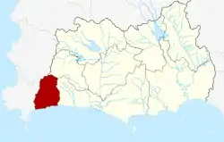
 District location in Rayong province | |
| Coordinates: 12°43′42″N 101°3′59″E / 12.72833°N 101.06639°E | |
| Country | Thailand |
| Province | Rayong |
| Seat | Ban Chang |
| Area | |
| • Total | 238.4 km2 (92.0 sq mi) |
| Population (2005) | |
| • Total | 49,189 |
| • Density | 206.3/km2 (534/sq mi) |
| Time zone | UTC+7 (ICT) |
| Postal code | 21130 |
| Geocode | 2102 |
Ban Chang (Thai: บ้านฉาง, pronounced [bâːn t͡ɕʰǎːŋ]) is the westernmost district (amphoe) of Rayong province, eastern Thailand.
History
The area originally was Tambon Phala of Mueang Rayong district. From 1963 on the US military used the U-Tapao Royal Thai Navy Airfield, thus the community grew bigger.
The government created Ban Chang minor district (king amphoe) on 7 May 1976 by splitting two tambons from Mueang District.[1] It was upgraded to be full district on 16 March 1985.[2]
Geography
Neighboring districts are (from the west clockwise) Sattahip, Bang Lamung of Chonburi province, Nikhom Phatthana and Mueang Rayong of Rayong Province. To the south is the Gulf of Thailand. Ban Chang also features three beaches with Phala Beach to the west, Phayun Beach in the center and Nam Rin Beach on the eastern side of the district, with Nam Rin being the longer beach of the three[3][4]
Administration
The district is divided into three sub-districts (tambons), which are further subdivided into 22 villages (mubans). Ban Chang is a town (thesaban mueang) and covers parts of the tambon Ban Chang and Phla. Samnak Thon is a township (thesaban tambon) which covers parts of tambon Samnak Thon. There are a further three tambon administrative organizations (TAO) responsible for non-municipal areas.
| No. | Name | Thai name | Villages | Pop. | |
|---|---|---|---|---|---|
| 1. | Samnak Thon | สำนักท้อน | 8 | 16,442 | |
| 2. | Phla | พลา | 7 | 9,432 | |
| 3. | Ban Chang | บ้านฉาง | 7 | 23,315 |
See also
References
- ↑ ประกาศกระทรวงมหาดไทย เรื่อง แบ่งท้องที่อำเภอเมืองระยอง จังหวัดระยอง ตั่งเป็นกิ่งอำเภอบ้านฉาง (PDF). Royal Gazette (in Thai). 93 (71 ง): 1038. 4 May 1976. Archived from the original (PDF) on 30 September 2007.
- ↑ พระราชกฤษฎีกาตั้งอำเภอเขาสวนกวาง อำเภอแปลงยาว อำเภอบ่อทอง อำเภอปะคำ และอำเภอบ้านฉาง พ.ศ. ๒๕๒๘ (PDF). Royal Gazette (in Thai). 102 (33 ก special): 7–9. 15 March 1985. Archived from the original (PDF) on 27 September 2007.
- ↑ "Nam Rin Beach". tourismthailand.org. Tourism Authority of Thailand. Retrieved 22 June 2021.
- ↑ "Nam Rin Beach". surprise-rayong.com. Surprise-Rayong. Retrieved 22 June 2021.
External links