52°02′53″N 0°56′53″E / 52.048°N 0.948°E
Babergh District | |
|---|---|
 Sudbury, the district's largest town | |
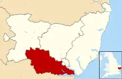
 Babergh shown within Suffolk | |
| Sovereign state | United Kingdom |
| Constituent country | England |
| Region | East of England |
| Non-metropolitan county | Suffolk |
| Status | Non-metropolitan district |
| Admin HQ | Ipswich |
| Incorporated | 1 April 1974 |
| Government | |
| • Type | Non-metropolitan district council |
| • Body | Babergh District Council |
| • MPs | James Cartlidge |
| Area | |
| • Total | 229.8 sq mi (595.2 km2) |
| • Rank | 60th (of 296) |
| Population (Census 2021) | |
| • Total | 92,300 |
| • Rank | 257th (of 296) |
| • Density | 400/sq mi (160/km2) |
| • Ethnicity | 98.7% White |
| Time zone | UTC0 (GMT) |
| • Summer (DST) | UTC+1 (BST) |
| ONS code | 42UB (ONS) E07000200 (GSS) |
| OS grid reference | TM021429 |
Babergh District (pronounced /ˈbeɪbə/, BAY-bə[1]) is a local government district in Suffolk, England. In 2021 it had a population of 92,300. The district is primarily a rural area, containing just two towns, being Sudbury and Hadleigh, which was the administrative centre until 2017 when the council moved to shared offices with neighbouring Mid Suffolk District Council in Ipswich, outside either district.[2][3][4] The district is named after the medieval Babergh Hundred which covered part of the area.
The district includes parts of two designated Areas of Outstanding Natural Beauty, being Dedham Vale, known for its association with painter John Constable, and Suffolk Coast and Heaths.
The neighbouring districts are East Suffolk, Ipswich, Mid Suffolk, West Suffolk, Braintree, Colchester and Tendring.
History
The district was created on 1 April 1974 under the Local Government Act 1972, covering five former districts which were all abolished at the same time:
- Cosford Rural District
- Hadleigh Urban District
- Melford Rural District
- Samford Rural District
- Sudbury Municipal Borough
Samford Rural District had been in the administrative county of East Suffolk prior to the reforms; the other districts had all been in West Suffolk.[5]
The new district was named Babergh after the medieval hundred of Babergh, which had covered part of the area.[6] Babergh Hundred is referred to in the Domesday Book of 1086; the modern district covers a larger area than the historic hundred, also covering the hundreds of Cosford and Samford. The council's logo now says "Babergh District Council – South Suffolk".
Governance
Babergh District Council | |
|---|---|
 | |
| Type | |
| Type | |
| Leadership | |
Arthur Charvonia since 2017[8] | |
| Structure | |
| Seats | 32 councillors |
Political groups |
|
| Elections | |
| First past the post | |
Last election | 4 May 2023 |
Next election | 6 May 2027 |
| Meeting place | |
 | |
| Endeavour House, 8 Russell Road, Ipswich, IP1 2BX | |
| Website | |
| www | |
Babergh District Council provides district-level services. County-level services are provided by Suffolk County Council.[9] The whole district is also covered by civil parishes, which form a third tier of local government.[10]
In 2011, Babergh and Mid Suffolk District Councils began working together, with one, fully integrated staff structure.[11]
Political control
The council has been under no overall control since the 2019 election. Following the 2023 election a coalition of the Greens, independents and Liberal Democrats formed to run the council.[12]
The first elections were held in 1973, initially operating as a shadow authority alongside the outgoing authorities until the new arrangements came into effect on 1 April 1974. Political control of the council since 1974 has been as follows:[13][14]
| Party in control | Years | |
|---|---|---|
| No overall control | 1974–2015 | |
| Conservative | 2015–2019 | |
| No overall control | 2019–present | |
Leadership
Prior to 2014 there was no formal position of leader of the council at Babergh, with political leadership provided instead by the chair of the policy and resources committee, or its successor, the strategy committee.[15] From 2014 onwards, the chair of the strategy committee was also given the title of leader.[16] The council then moved from a committee system to a leader and cabinet model in 2017, giving the leader additional powers to make executive decisions.[17] The leaders (or chairs of policy and resources / strategy committees) since 1998 have been:[18]
| Councillor | Party | From | To | |
|---|---|---|---|---|
| Colin Spence | Conservative | 1998 | 2003 | |
| Sue Carpendale | Liberal Democrats | 2003 | 2005 | |
| Nick Ridley[19] | Conservative | 2005 | 2011 | |
| Jennie Jenkins[20] | Conservative | 19 May 2011 | 19 Dec 2017 | |
| John Ward[21] | Conservative | 4 Jan 2018 | 25 Apr 2022 | |
| Independent | 25 Apr 2022 | 23 May 2023 | ||
| David Busby | Liberal Democrats | 23 May 2023 | ||
Composition
Following the 2023 election, the composition of the council was:[22]
| Party | Councillors | |
|---|---|---|
| Green | 10 | |
| Independent | 9 | |
| Conservative | 7 | |
| Liberal Democrats | 5 | |
| Labour | 1 | |
| Total | 32 | |
The next election is due in 2027.
Elections
Since the last boundary changes in 2019 the council has comprised 32 councillors representing 24 wards, with each ward electing one, two or three councillors. Elections are held every four years.[23]
Premises
Since 2017 Babergh and Mid Suffolk councils have their combined headquarters at Endeavour House in Ipswich, sharing the building with Suffolk County Council.[24]

When the council was first created it inherited offices in Sudbury, Hadleigh and Ipswich from its predecessor councils. The council initially based itself at the former Cosford Rural District Council's offices at 32 High Street in Hadleigh.[25][26] The council built itself a new headquarters on Corks Lane in Hadleigh, incorporating existing cottages and granaries into the new building. The new complex was formally opened on 4 June 1982.[27]
Geography

The southern boundary of the district is marked almost exclusively by the River Stour, which also forms the border with Essex, and it is separated from East Suffolk by the River Orwell. The eastern part of the district forms a peninsula between the two tidal rivers, coming to a point at Shotley Gate.

'Constable Country' is cognate with a large tract of Babergh: drawing visitors to the Dedham Vale, a designated Area of Outstanding Natural Beauty, and the well-preserved villages of Long Melford, Lavenham and Kersey. The district also includes part of the built-up area of Ipswich at Pinewood.
Demography
Babergh's population size has increased by 5.2%, from around 87,700 in 2011 to 92,300 in 2021[28] and covers an area of approximately 230 square miles (600 km2).[29]
Towns and parishes


The whole district is covered by civil parishes. The parish councils for Sudbury and Hadleigh have declared their parishes to be towns, allowing them to take the style "town council". Some of the smaller parishes have a parish meeting rather than a parish council.[30]
References
- ↑ "Babergh District Council – Summary". Archived from the original on 26 January 2010.
- ↑ Estimates of Total Populations of Areas of Suffolk Archived 19 December 2008 at the Wayback Machine Suffolk County Council
- ↑ "Contact Us » Babergh Mid Suffolk". babergh.gov.uk.
- ↑ Geater, Paul. "Babergh and Mid Suffolk councils set to move to Ipswich in September". Ipswich Star. Archived from the original on 12 February 2020. Retrieved 6 February 2018.
- ↑ "The English Non-metropolitan District (Definition) Order 1972", legislation.gov.uk, The National Archives, SI 1972/2039, retrieved 17 November 2023
- ↑ "The English Non-metropolitan Districts (Names) Order 1973", legislation.gov.uk, The National Archives, SI 1973/551, retrieved 3 January 2024
- ↑ "Council minutes, 23 May 2023". Babergh District Council. Retrieved 3 January 2024.
- ↑ "New council chief hired". Suffolk News. 26 October 2016. Retrieved 3 January 2024.
- ↑ "Local Government Act 1972", legislation.gov.uk, The National Archives, 1972 c. 70, retrieved 31 May 2023
- ↑ "Election Maps". Ordnance Survey. Retrieved 25 July 2023.
- ↑ "One Council » Babergh Mid Suffolk". midsuffolk.gov.uk. Retrieved 27 January 2022.
- ↑ Malina, Thomas (2 June 2023). "New coalition cabinet appointed at Babergh District Council". Suffolk News. Retrieved 3 January 2024.
- ↑ "Compositions calculator". The Elections Centre. Retrieved 9 September 2022.
- ↑ "England council elections". BBC News Online. Archived from the original on 19 May 2011. Retrieved 9 June 2011.
- ↑ "Council leader defends allowances rise". East Anglian Daily Times. 1 December 2003. Retrieved 22 June 2022.
Babergh... its most senior member, the chairman of strategy...
- ↑ "Council minutes, 22 April 2014" (PDF). Babergh District Council. Retrieved 22 June 2022.
- ↑ "Babergh District Council unveils new Cabinet and governance model". Suffolk News. 20 June 2017. Retrieved 22 June 2022.
- ↑ "Council minutes". Babergh District Council. Retrieved 22 June 2022.
- ↑ Geater, Paul (3 April 2020). "Tributes to Nick Ridley - Suffolk hospice founder and community leader". East Anglian Daily Times. Retrieved 3 January 2024.
- ↑ "Council minutes, 19 May 2011" (PDF). Babergh District Council. Retrieved 22 June 2022.
- ↑ Noble, Jason (27 April 2022). "Fresh cabinet unveiled after party rifts at Babergh District Council". East Anglian Daily Times. Retrieved 22 June 2022.
- ↑ "Local elections 2023: live council results for England". The Guardian.
- ↑ "The Babergh (Electoral Changes) Order 2018", legislation.gov.uk, The National Archives, SI 2018/1315, retrieved 3 January 2024
- ↑ Geater, Paul (7 August 2017). "Babergh and Mid Suffolk councils set to move to Ipswich in September". East Anglian Daily Times. Archived from the original on 7 August 2017. Retrieved 3 January 2024.
- ↑ "No. 46145". The London Gazette. 6 December 1973. p. 14525.
- ↑ Municipal Year Book. London: Municipal Journal. 1976. p. 639.
- ↑ Eeles, Barbara (3 June 1982). "This is Babergh". Suffolk Free Press. Sudbury. p. 9. Retrieved 3 January 2024.
- ↑ "How the population changed in Babergh, Census 2021 – ONS". ons.gov.uk. Retrieved 9 November 2022.
- ↑ "District population 2011". Neighbourhood Statistics. Office for National Statistics. Archived from the original on 12 October 2016. Retrieved 15 August 2016.
- ↑ "Parish Council contacts". Babergh District Council. Retrieved 3 January 2024.
