Bílé Podolí | |
|---|---|
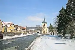
 Centre of Bílé Podolí | |
 Flag  Coat of arms | |
 Bílé Podolí Location in the Czech Republic | |
| Coordinates: 49°57′24″N 15°29′28″E / 49.95667°N 15.49111°E | |
| Country | |
| Region | Central Bohemian |
| District | Kutná Hora |
| First mentioned | 1307 |
| Area | |
| • Total | 15.29 km2 (5.90 sq mi) |
| Elevation | 230 m (750 ft) |
| Population (2023-01-01)[1] | |
| • Total | 601 |
| • Density | 39/km2 (100/sq mi) |
| Time zone | UTC+1 (CET) |
| • Summer (DST) | UTC+2 (CEST) |
| Postal codes | 285 72, 286 01 |
| Website | www |
Bílé Podolí is a market town in Kutná Hora District in the Central Bohemian Region of the Czech Republic. It has about 600 inhabitants.
Administrative parts
The villages of Lovčice and Zaříčany are administrative parts of Bílé Podolí. Lovčice forms an exclave of the municipal territory.
Geography
Bílé Podolí is located about 15 kilometres (9 mi) east of Kutná Hora and 21 km (13 mi) west of Pardubice. It lies in a flat agricultural landscape of the Central Elbe Table. In the northeast, the slopes of the Iron Mountains begin and include the highest point of Bílé Podolí, a contour line at 290 m (950 ft) above sea level. The Doubrava River flows along the western municipal border.
History
The first written mention of Bílé Podolí is from 1307. The village was promoted to a market town in 1687 by Emperor Leopold I.[2]
Demographics
|
|
| ||||||||||||||||||||||||||||||||||||||||||||||||||||||
| Source: Censuses[3][4] | ||||||||||||||||||||||||||||||||||||||||||||||||||||||||
Transport
The I/19 road from Čáslav to Chrudim and Vysoké Mýto runs between Bílé Podolí and its exclave of Lovčice.
Sights
The main landmark of Bílé Podolí is the Church of Saint Wenceslaus. It was built in the late Gothic style probably at the end of the 14th century. The early Baroque reconstruction took place in the 1670s, further modifications were made after the fire in 1713. In 1821, the church was rebuilt into its current form with a Neoclassical façade.[5]
References
- ↑ "Population of Municipalities – 1 January 2023". Czech Statistical Office. 2023-05-23.
- ↑ "Historie městyse Bílé Podolí" (in Czech). Městys Bílé Podolí. Retrieved 2023-03-07.
- ↑ "Historický lexikon obcí České republiky 1869–2011 – Okres Kutná Hora" (in Czech). Czech Statistical Office. 2015-12-21. pp. 1–2.
- ↑ "Population Census 2021: Population by sex". Public Database. Czech Statistical Office. 2021-03-27.
- ↑ "Kostel sv. Václava" (in Czech). National Heritage Institute. Retrieved 2023-03-07.