Department of Atlántico
Departamento del Atlántico | |
|---|---|
 Flag  Coat of arms | |
| Motto(s): Compromiso para una vida digna (English: Commitment for a worthy life) | |
| Anthem: Himno del Atlántico | |
.svg.png.webp) Atlántico shown in red | |
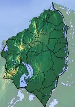
 Topography of the department | |
| Country | |
| Region | Caribbean Region |
| Established | 1910 |
| Capital | Barranquilla |
| Government | |
| • Governor | Elsa Noguera 2020–2023 (Radical Change) |
| Area | |
| • Total | 3,388 km2 (1,308 sq mi) |
| • Rank | 30th |
| Population (2018)[1] | |
| • Total | 2,535,517 |
| • Rank | 5th |
| • Density | 750/km2 (1,900/sq mi) |
| Time zone | UTC-05 |
| ISO 3166 code | CO-ATL |
| Municipalities | 23 |
| HDI (2019) | 0.786[2] high · 4th of 33 |
| Website | atlantico.gov.co |
| Year | Pop. | ±% |
|---|---|---|
| 1973 | 964,087 | — |
| 1985 | 1,478,213 | +53.3% |
| 1993 | 1,837,468 | +24.3% |
| 2005 | 2,166,156 | +17.9% |
| 2018 | 2,535,517 | +17.1% |
| Source:[3] | ||
Atlántico (Spanish pronunciation: [aðˈlantiko], English: Atlantic) is a department of Colombia, located in northern Colombia with the Caribbean Sea to its north, the Bolívar Department to its west and south separated by the Canal del Dique, and the Magdalena Department to its east separated by the Magdalena River. Despite being the third smallest in the country, the department is among the most densely populated, with a population of 2,535,517.
The department's capital and most-populous city is Barranquilla with a population of 1,327,209. Soledad and Malambo are also significant population centers within Atlántico, constituting integral parts of the Barranquilla metropolitan area.
Governors
Politics
Administrative divisions
Municipalities
.svg.png.webp)
Education
Higher education
The University of Atlántico, with 22,790 students in 2021, stands as the largest higher education institution by student population in the department.
In September 2023, the University of the Coast was ranked second among the top universities in the country, while the University of the North ranked fifteenth.
Notable people
- Alci Acosta, musician
- Andrés Roa, association football player
- Antonio Rada, former association football player
- Arturo Segovia, former association football player
- Carlos Bacca, association football player, one of Colombia’s top all-time strikers, having scored over 300 goals for both club and country throughout his professional career
- Carlos Rodado, politician
- Checo Acosta, musician and prominent figure in the Carnival of Barranquilla
- Evaristo Sourdis, politician who held several significant positions
- Fredy Montero, association football player
- Homer Martínez, association football player
- Juan José Nieto, politician, first Afro-Colombian president
- Luis Muriel, association football player
- Luis Sandoval, association football player
- Mauro Manotas, association football player
- Melissa Martínez, sports journalist and presenter
- Pacho Galán, musician
References
- ↑ "DANE". Archived from the original on November 13, 2009. Retrieved February 13, 2013.
- ↑ "Sub-national HDI – Area Database – Global Data Lab". hdi.globaldatalab.org. Retrieved 2018-09-13.
- ↑ "Reloj de Población". DANE. Departamento Administrativo Nacional de Estadísitica. Archived from the original on 16 January 2018. Retrieved 6 July 2017.
External links
- (in Spanish) Government of Atlantico Department official website
