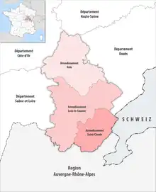
Map of arrondissements of the Jura department.
The 3 arrondissements of the Jura department are:[1]
- Arrondissement of Dole, (subprefecture: Dole) with 190 communes.[2] The population of the arrondissement was 83,474 in 2013.
- Arrondissement of Lons-le-Saunier, (prefecture of the Jura department: Lons-le-Saunier) with 249 communes.[3] The population of the arrondissement was 125,876 in 2013.
- Arrondissement of Saint-Claude, (subprefecture: Saint-Claude) with 55 communes.[4] The population of the arrondissement was 51,152 in 2013.
History
In 1800 the arrondissements of Lons-le-Saunier, Dole, Poligny and Saint-Claude were established. The arrondissement of Poligny was disbanded in 1926.[5] In May 2006 the arrondissement of Dole absorbed the canton of Villers-Farlay from the arrondissement of Lons-le-Saunier, and it lost the canton of Chaumergy to the arrondissement of Lons-le-Saunier.[5]
The borders of the arrondissements of Jura were modified in January 2017:[6]
- 66 communes from the arrondissement of Lons-le-Saunier to the arrondissement of Dole
- four communes from the arrondissement of Saint-Claude to the arrondissement of Lons-le-Saunier
References
- ↑ "Populations légales 2016" (PDF). INSEE. December 2018. Retrieved 2019-10-24.
- ↑ "Arrondissement de Dole (391)". INSEE. Retrieved 2019-10-01.
- ↑ "Arrondissement de Lons-le-Saunier (392)". INSEE. Retrieved 2019-10-01.
- ↑ "Arrondissement de Saint-Claude (393)". INSEE. Retrieved 2019-10-01.
- 1 2 Historique du Jura
- ↑ "Arrêté n°17-08 BAG portant modification des limites territoriales des arrondissements du département du JURA, 7 January 2017" (PDF). pp. 92–95. Retrieved 2021-04-05.
Article 2 Le prèsent arrêté annule et remplace l'arrêté n°16-818 BAG du 27 décembre 2016 (Section 2 This Order cancels and replaces Order No. 16-818 BAG dated December 27, 2016)
This article is issued from Wikipedia. The text is licensed under Creative Commons - Attribution - Sharealike. Additional terms may apply for the media files.