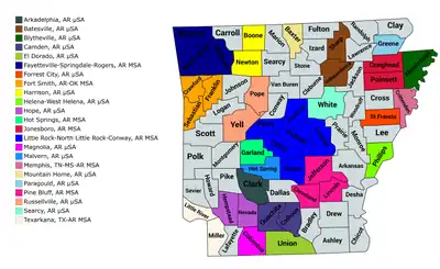
Map of the 23 core-based statistical areas in Arkansas.
An enlargeable map of the 23 core-based statistical areas in Arkansas.[1]

The U.S. State of Arkansas currently has 27 statistical areas that have been delineated by the Office of Management and Budget (OMB). On March 6, 2020, the OMB delineated four combined statistical areas, eight metropolitan statistical areas, and 15 micropolitan statistical areas in Arkansas.[1]

Statistical areas

The Office of Management and Budget (OMB) has designated more than 1,000 statistical areas for the United States and Puerto Rico.[2] These statistical areas are important geographic delineations of population clusters used by the OMB, the United States Census Bureau, planning organizations, and federal, state, and local government entities.

The OMB defines a core-based statistical area (commonly referred to as a CBSA) as "a statistical geographic entity consisting of the county or counties (or county-equivalents) associated with at least one core[lower-alpha 1] of at least 10,000 population, plus adjacent counties having a high degree of social and economic integration with the core as measured through commuting ties with the counties containing the core."[2] The OMB further divides core-based statistical areas into metropolitan statistical areas (MSAs) that have "a population of at least 50,000" and micropolitan statistical areas (μSAs) that have "a population of at least 10,000, but less than 50,000."[2]

The OMB defines a combined statistical area (CSA) as "a geographic entity consisting of two or more adjacent core-based statistical areas with employment interchange measures[lower-alpha 2] of at least 15%."[2] The primary statistical areas (PSAs) include all combined statistical areas and any core-based statistical area that is not a constituent of a combined statistical area.

Table

The table below describes the 27 United States statistical areas and 75 counties of the State of Arkansas with the following information:[3]

  1. The combined statistical area (CSA) as designated by the OMB.[1]
  2. The CSA population according to the 2020 US Census.[4]
  3. The core based statistical area (CBSA)[2] as designated by the OMB.[1]
  4. The CBSA population according to the 2020 US Census.[4]
  5. The county name.
  6. The county population according to the 2020 US Census.[4]
The 27 United States statistical areas and 75 counties of the State of Arkansas

Combined Statistical Area 2020 Population Core Based Statistical Area 2020 Population County 2020 Population
Little Rock-North Little Rock, AR CSA 912,604 Little Rock-North Little Rock-Conway, AR MSA 748,031 Pulaski County, Arkansas 399,125
Faulkner County, Arkansas 123,498
Saline County, Arkansas 123,416
Lonoke County, Arkansas 74,015
Grant County, Arkansas 17,958
Perry County, Arkansas 10,019
Pine Bluff, AR MSA 87,751 Jefferson County, Arkansas 67,260
Lincoln County, Arkansas 12,941
Cleveland County, Arkansas 7,550
Searcy, AR μSA 76,822 White County, Arkansas 76,822
none Fayetteville-Springdale-Rogers, AR MSA 546,725 Benton County, Arkansas 284,333
Washington County, Arkansas 245,871
Madison County, Arkansas 16,521
Fort Smith, AR-OK MSA 244,310
205,029
Sebastian County, Arkansas 127,799
Crawford County, Arkansas 60,133
Sequoyah County, Oklahoma 39,281
Franklin County, Arkansas 17,097
Jonesboro-Paragould, AR CSA 179,932 Jonesboro, AR MSA 134,196 Craighead County, Arkansas 111,231
Poinsett County, Arkansas 22,965
Paragould, AR μSA 45,736 Greene County, Arkansas 45,736
Hot Springs-Malvern, AR CSA 133,220 Hot Springs, AR MSA 100,180 Garland County, Arkansas 100,180
Malvern, AR μSA 33,040 Hot Spring County, Arkansas 33,040
none Russellville, AR μSA 83,644 Pope County, Arkansas 63,381
Yell County, Arkansas 20,263
Memphis-Forrest City, TN-MS-AR CSA 1,360,869
71,253
Memphis, TN-MS-AR MSA 1,337,779
48,163
Shelby County, Tennessee 929,744
DeSoto County, Mississippi 185,314
Tipton County, Tennessee 60,970
Crittenden County, Arkansas 48,163
Fayette County, Tennessee 41,990
Marshall County, Mississippi 33,752
Tate County, Mississippi 28,064
Tunica County, Mississippi 9,782
Forrest City, AR μSA 23,090 St. Francis County, Arkansas 23,090
none Batesville, AR μSA 55,209 Independence County, Arkansas 37,938
Sharp County, Arkansas 17,271
Texarkana, TX-AR MSA 147,519
54,626
Bowie County, Texas 92,893
Miller County, Arkansas 42,600
Little River County, Arkansas 12,026
Harrison, AR μSA 44,598 Boone County, Arkansas 37,373
Newton County, Arkansas 7,225
Mountain Home, AR μSA 41,627 Baxter County, Arkansas 41,627
Blytheville, AR μSA 40,685 Mississippi County, Arkansas 40,685
El Dorado, AR μSA 39,054 Union County, Arkansas 38,682
Hope, AR μSA 28,375 Hempstead County, Arkansas 20,065
Nevada County, Arkansas 8,310
Camden, AR μSA 27,389 Ouachita County, Arkansas 22,650
Calhoun County, Arkansas 4,739
Magnolia, AR μSA 22,801 Columbia County, Arkansas 22,801
Arkadelphia, AR μSA 21,446 Clark County, Arkansas 21,446
Helena-West Helena, AR μSA 16,568 Phillips County, Arkansas 16,568
none Carroll County, Arkansas 28,260
Johnson County, Arkansas 25,749
Cleburne County, Arkansas 24,711
Logan County, Arkansas 21,131
Conway County, Arkansas 20,715
Polk County, Arkansas 19,221
Ashley County, Arkansas 19,062
Randolph County, Arkansas 18,571
Drew County, Arkansas 17,350
Arkansas County, Arkansas 17,149
Cross County, Arkansas 16,833
Marion County, Arkansas 16,826
Jackson County, Arkansas 16,755
Lawrence County, Arkansas 16,216
Sevier County, Arkansas 15,839
Van Buren County, Arkansas 15,796
Clay County, Arkansas 14,552
Izard County, Arkansas 13,577
Howard County, Arkansas 12,785
Stone County, Arkansas 12,359
Fulton County, Arkansas 12,075
Desha County, Arkansas 11,395
Bradley County, Arkansas 10,545
Chicot County, Arkansas 10,208
Pike County, Arkansas 10,171
Scott County, Arkansas 9,836
Lee County, Arkansas 8,600
Montgomery County, Arkansas 8,484
Prairie County, Arkansas 8,282
Searcy County, Arkansas 7,828
Monroe County, Arkansas 6,799
Dallas County, Arkansas 6,482
Lafayette County, Arkansas 6,308
Woodruff County, Arkansas 6,269
State of Arkansas 3,011,524

See also

Notes

  1. The OMB defines a core as "a densely settled concentration of population, comprising an Urban Area (of 10,000 or more population) delineated by the Census Bureau, around which a core-based statistical area is delineated."[2]
  2. The OMB defines the employment interchange measure as "the sum of the percentage of workers living in the smaller entity who work in the larger entity plus the percentage of employment in the smaller entity that is accounted for by workers who reside in the larger entity."[2]

References

  1. 1 2 3 4 Revised Delineations of Metropolitan Statistical Areas, Micropolitan Statistical Areas, and Combined Statistical Areas, and Guidance on Uses of the Delineations of These Areas (March 6, 2020). "0MB BULLETIN NO. 20-01" (PDF). Office of Management and Budget. Retrieved December 6, 2021.{{cite web}}: CS1 maint: multiple names: authors list (link)
  2. 1 2 3 4 5 6 7 "2020 Standards for Delineating Core Based Statistical Areas". Office of Management and Budget. July 16, 2021. Retrieved December 6, 2021.
  3. An out-of-state area and its population are displayed in green. An area that extends into more than one state is displayed in teal. A teal population number over a black population number show the total population versus the in-state population.
  4. 1 2 3 "2020 Census Redistricting Data". United States Census Bureau. September 2021. Retrieved January 9, 2022.

34°53′38″N 92°26′33″W / 34.8938°N 92.4426°W / 34.8938; -92.4426 (State of Arkansas)

This article is issued from Wikipedia. The text is licensed under Creative Commons - Attribution - Sharealike. Additional terms may apply for the media files.