Appomattox County | |
|---|---|
 The Appomattox County Courthouse in October 2007 | |
 Flag | |
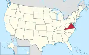
 Location within the U.S. state of Virginia | |
 Virginia's location within the U.S. | |
| Coordinates: 37°21′32″N 78°49′35″W / 37.358973°N 78.826438°W | |
| Country | |
| State | |
| Founded | 1845 |
| Named for | Appomattox River |
| Seat | Appomattox |
| Largest town | Appomattox |
| Area | |
| • Total | 335 sq mi (870 km2) |
| • Land | 333 sq mi (860 km2) |
| • Water | 1.2 sq mi (3 km2) 0.4% |
| Population (2020) | |
| • Total | 16,119 |
| • Density | 48/sq mi (19/km2) |
| Time zone | UTC−5 (Eastern) |
| • Summer (DST) | UTC−4 (EDT) |
| Congressional district | 5th |
| Website | www |
Appomattox County is a United States county located in the Piedmont region and near the center of the Commonwealth of Virginia. The county is part of the Lynchburg, VA Metropolitan Statistical Area, and its county seat is the town of Appomattox.[1]
Appomattox County was created in 1845 from parts of four other Virginia counties. The name of the county comes from the Appamatuck Indians, who lived in the area. As of the 2020 census, the population was 16,119.[2]
History

Appomattox County was formed in 1845 from Buckingham, Prince Edward, Campbell, and Charlotte counties. In 1848, another part from Campbell County was added. It was named for the Appomattox River, which in turn was named for the Appamatuck, a historic Native American tribes in Virginia of the Algonquian-speaking Powhatan Confederacy.[3]
Appomattox came to national attention on April 9, 1865, when Confederate General Robert E. Lee met with Union General Ulysses S. Grant at the village of Appomattox Court House to accept Lee's surrender. The surrender of Lee, which effectively ended the American Civil War, took place at the McLean House, home of Wilmer McLean.[3]
Geography
According to the U.S. Census Bureau, the county has a total area of 335 square miles (870 km2), of which 333 square miles (860 km2) is land and 1.2 square miles (3.1 km2) (0.4%) is water.[4]
Adjacent counties
- Nelson County, Virginia - north
- Buckingham County, Virginia - northeast
- Prince Edward County, Virginia - southeast
- Charlotte County, Virginia - south
- Campbell County, Virginia - southwest
- Amherst County, Virginia - northwest
National protected area
Major highways
Demographics
| Census | Pop. | Note | %± |
|---|---|---|---|
| 1850 | 9,193 | — | |
| 1860 | 8,889 | −3.3% | |
| 1870 | 8,950 | 0.7% | |
| 1880 | 10,080 | 12.6% | |
| 1890 | 9,589 | −4.9% | |
| 1900 | 9,662 | 0.8% | |
| 1910 | 8,904 | −7.8% | |
| 1920 | 9,255 | 3.9% | |
| 1930 | 8,402 | −9.2% | |
| 1940 | 9,020 | 7.4% | |
| 1950 | 8,764 | −2.8% | |
| 1960 | 9,148 | 4.4% | |
| 1970 | 9,784 | 7.0% | |
| 1980 | 11,971 | 22.4% | |
| 1990 | 12,298 | 2.7% | |
| 2000 | 13,705 | 11.4% | |
| 2010 | 14,973 | 9.3% | |
| 2020 | 16,119 | 7.7% | |
| U.S. Decennial Census[5] 1790-1960[6] 1900-1990[7] 1990-2000[8] 2010[9] 2020[10] | |||
2020 census
| Race / Ethnicity | Pop 2010[9] | Pop 2020[10] | % 2010 | % 2020 |
|---|---|---|---|---|
| White alone (NH) | 11,483 | 12,155 | 76.69% | 75.41% |
| Black or African American alone (NH) | 2,998 | 2,877 | 20.02% | 17.85% |
| Native American or Alaska Native alone (NH) | 28 | 50 | 0.19% | 0.31% |
| Asian alone (NH) | 35 | 42 | 0.23% | 0.26% |
| Pacific Islander alone (NH) | 4 | 3 | 0.03% | 0.02% |
| Some Other Race alone (NH) | 23 | 84 | 0.15% | 0.52% |
| Mixed Race/Multi-Racial (NH) | 235 | 564 | 1.57% | 3.50% |
| Hispanic or Latino (any race) | 167 | 344 | 1.12% | 2.13% |
| Total | 14,973 | 16,119 | 100.00% | 100.00% |
Note: the US Census treats Hispanic/Latino as an ethnic category. This table excludes Latinos from the racial categories and assigns them to a separate category. Hispanics/Latinos can be of any race.
2000 Census
As of the census[11] of 2000, there were 13,705 people, 5,322 households, and 4,012 families residing in the county. The population density was 41 people per square mile (16 people/km2). There were 5,828 housing units at an average density of 18 units per square mile (6.9 units/km2). The racial makeup of the county was 75.94% White, 22.91% Black or African American, 0.13% Native American, 0.17% Asian, 0.02% Pacific Islander, 0.26% from other races, and 0.56% from two or more races. 0.47% of the population were Hispanic or Latino of any race.
There were 5,322 households, out of which 32.20% had children under the age of 18 living with them, 59.70% were married couples living together, 11.50% had a female householder with no husband present, and 24.60% were non-families. 21.30% of all households were made up of individuals, and 10.00% had someone living alone who was 65 years of age or older. The average household size was 2.55 and the average family size was 2.94.
In the county, the population was spread out, with 24.70% under the age of 18, 7.10% from 18 to 24, 27.80% from 25 to 44, 25.60% from 45 to 64, and 14.80% who were 65 years of age or older. The median age was 39 years. For every 100 females there were 94.80 males. For every 100 females age 18 and over, there were 91.10 males.
The median income for a household in the county was $36,507, and the median income for a family was $41,563. Males had a median income of $31,428 versus $21,367 for females. The per capita income for the county was $18,086. 11.40% of the population and 8.70% of families were below the poverty line. Out of the total population, 14.10% of those under the age of 18 and 21.50% of those 65 and older were living below the poverty line.
Government
Board of Supervisors
- Appomattox River district: William H. Hogan, Vice-chairman (I)
- Courthouse district: Samuel E. Carter Chairman (I)
- Falling River district: John F. Hinkle
- Piney Mountain district: Watkins Abbitt Jr.,(I)
- Wreck Island district: Trevor L. Hipps
Constitutional officers
- Clerk of the Circuit Court: Janet A. Hix (I)
- Commissioner of the Revenue: Sara R. Henderson (I)
- Commonwealth's Attorney: Leslie M. Fleet (I)
- Sheriff: Donald D. Simpson (I)
- Treasurer: Victoria C. Phelps (I)
Appomattox County is represented by Republican Mark Peake, in the Virginia Senate, Republican C. Matt Farris in the Virginia House of Delegates, and Republican Bob Good the U.S. House of Representatives.
| Year | Republican | Democratic | Third party | |||
|---|---|---|---|---|---|---|
| No. | % | No. | % | No. | % | |
| 2020 | 6,702 | 72.31% | 2,418 | 26.09% | 148 | 1.60% |
| 2016 | 5,715 | 71.46% | 2,023 | 25.30% | 259 | 3.24% |
| 2012 | 5,340 | 67.30% | 2,453 | 30.91% | 142 | 1.79% |
| 2008 | 4,903 | 64.26% | 2,641 | 34.61% | 86 | 1.13% |
| 2004 | 4,366 | 65.60% | 2,191 | 32.92% | 98 | 1.47% |
| 2000 | 3,654 | 61.65% | 2,132 | 35.97% | 141 | 2.38% |
| 1996 | 2,625 | 47.93% | 2,239 | 40.88% | 613 | 11.19% |
| 1992 | 2,830 | 50.36% | 1,919 | 34.15% | 871 | 15.50% |
| 1988 | 3,205 | 63.59% | 1,740 | 34.52% | 95 | 1.88% |
| 1984 | 3,386 | 68.65% | 1,498 | 30.37% | 48 | 0.97% |
| 1980 | 2,548 | 60.42% | 1,492 | 35.38% | 177 | 4.20% |
| 1976 | 1,964 | 50.84% | 1,702 | 44.06% | 197 | 5.10% |
| 1972 | 2,788 | 78.20% | 684 | 19.19% | 93 | 2.61% |
| 1968 | 1,753 | 43.42% | 756 | 18.73% | 1,528 | 37.85% |
| 1964 | 2,444 | 64.47% | 1,339 | 35.32% | 8 | 0.21% |
| 1960 | 951 | 43.07% | 1,240 | 56.16% | 17 | 0.77% |
| 1956 | 853 | 40.89% | 1,079 | 51.73% | 154 | 7.38% |
| 1952 | 929 | 49.13% | 957 | 50.61% | 5 | 0.26% |
| 1948 | 238 | 14.29% | 1,182 | 70.95% | 246 | 14.77% |
| 1944 | 270 | 19.49% | 1,109 | 80.07% | 6 | 0.43% |
| 1940 | 215 | 15.77% | 1,144 | 83.93% | 4 | 0.29% |
| 1936 | 204 | 12.85% | 1,375 | 86.64% | 8 | 0.50% |
| 1932 | 204 | 15.26% | 1,123 | 83.99% | 10 | 0.75% |
| 1928 | 446 | 33.51% | 885 | 66.49% | 0 | 0.00% |
| 1924 | 101 | 9.41% | 952 | 88.72% | 20 | 1.86% |
| 1920 | 190 | 18.41% | 837 | 81.10% | 5 | 0.48% |
| 1916 | 133 | 15.91% | 700 | 83.73% | 3 | 0.36% |
| 1912 | 28 | 3.81% | 654 | 89.10% | 52 | 7.08% |
Communities
Towns
Census-designated place
- Concord (primarily in Campbell County)
Other unincorporated communities
- Beckham
- Bent Creek
- Bowler
- Chap
- Evergreen
- Flood
- Fore Store
- Hixburg
- Hollywood
- Hurtsville
- Oakville
- Promise Land
- Spout Spring
- Spring Mills
- Stonewall
- Vera
See also
References
- ↑ "Find a County". National Association of Counties. Archived from the original on May 31, 2011. Retrieved June 7, 2011.
- ↑ "Appomattox County, Virginia". United States Census Bureau. Retrieved January 30, 2022.
- 1 2 "History of Appomattox County". Appomattox County, Virginia. March 19, 2012. Archived from the original on December 31, 2013. Retrieved December 29, 2013.
- ↑ "US Gazetteer files: 2010, 2000, and 1990". United States Census Bureau. February 12, 2011. Retrieved April 23, 2011.
- ↑ "Census of Population and Housing from 1790-2000". US Census Bureau. Retrieved January 24, 2022.
- ↑ "Historical Census Browser". University of Virginia Library. Retrieved December 31, 2013.
- ↑ "Population of Counties by Decennial Census: 1900 to 1990". United States Census Bureau. Retrieved December 31, 2013.
- ↑ "Census 2000 PHC-T-4. Ranking Tables for Counties: 1990 and 2000" (PDF). United States Census Bureau. Archived (PDF) from the original on October 9, 2022. Retrieved December 31, 2013.
- 1 2 "P2 HISPANIC OR LATINO, AND NOT HISPANIC OR LATINO BY RACE - 2010: DEC Redistricting Data (PL 94-171) - Appomattox County, Virginia". United States Census Bureau.
- 1 2 "P2 HISPANIC OR LATINO, AND NOT HISPANIC OR LATINO BY RACE - 2020: DEC Redistricting Data (PL 94-171) - Appomattox County, Virginia". United States Census Bureau.
- ↑ "U.S. Census website". United States Census Bureau. Retrieved May 14, 2011.
- ↑ Leip, David. "Dave Leip's Atlas of U.S. Presidential Elections". uselectionatlas.org. Retrieved December 9, 2020.