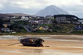
An Bun Beag (anglicised as Bunbeg), meaning "the small river mouth",[1] is a small Gaeltacht village and townland in County Donegal, Ireland. It is officially the smallest townland in Gaoth Dobhair (Gweedore), but today the name Bunbeg is used to describe a large region of the parish. It is situated between Derrybeg and the townland of Dore and is home to many of Gweedore's amenities and businesses. The Clady River (Irish: An Chláidigh) flows into the Crolly River (also known as the Gweedore River) beside Bunbeg Quay, on the south-western outskirts of Bunbeg.[2]
There is a ferry service from Bunbeg to nearby Tory Island.[3]
Storm
On Tuesday, 23 June 2009, a severe thunderstorm struck the villages of Bunbeg and Derrybeg and other parts of Gweedore. It lasted for several hours and caused two rivers to burst their banks, flooding houses and businesses, and damaging roads and bridges. Lightning strikes damaged power lines and mobile phone services, causing those trapped by the floods to be unable to communicate.[4][5] Described as the worst storm 'in living memory', it was also the most severe since 1880 when 5 people drowned in Derrybeg. While the highly localised nature of the storm meant the bulk of the rainfall missed the network of rain gauges, the Irish Meteorological Service estimated that up to 60 mm (2.4 in) of rain fell between 2pm and 6pm of 23 June 2009.[5][6]
Appearances in music
Bunbeg is mentioned in the song "Left in Peace" from the album Finisterres (1997) by Héritage des Celtes.
References
- ↑ Placenames (Ceantair Ghaeltachta) Order 2004
- ↑ Discovery Series Sheet 1 (Fourth Edition). Ordnance Survey of Ireland (O.S.I.), Dublin, 2012.
- ↑ "Tory island ferry". Archived from the original on 10 February 2015. Retrieved 30 July 2015.
- ↑ "Horror storms flood west Donegal"
- 1 2 Donegal Democrat, Clean up underway after freak flash flood in Gweedore, 24 June 2009 Archived 17 February 2013 at archive.today
- ↑ Met Service report on the flood
