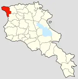
Amasia District
Ամասիայի շրջան | |
|---|---|
 The Amasia District in Armenia | |
| Country | |
| Established | 9 September 1930 |
| Abolished | 11 April 1995 |
| Capital | Amasia |
| Area | |
| • Total | 534 km2 (206 sq mi) |
| Population (1989) | |
| • Total | 6,342 |
| • Density | 12/km2 (31/sq mi) |
The Amasia District (Armenian: Ամասիայի շրջան) was a raion (district) of the Armenian Soviet Socialist Republic from 1930 and later in 1991 of the Republic of Armenia until its disestablishment in 1995. The Amasia District today constitutes a northwestern part of the Shirak Province (marz) and bordered the Kars Province of the Republic of Turkey to the west, and the Javakheti region of Georgia to the north. Its administrative center was the town Amasia.
History
The Amasia District was formed on the territory of the Armenian SSR in 1930, originally part of the Leninakan uezd (previously Alexandropol uezd).[1] Amasia is the only territory of the former Kars Oblast retained by Armenia as the rest of it was annexed by Turkey through the Treaty of Kars.[2]
The district and its capital were originally known as Aghbaba (Armenian: Աղբաբա) before being renamed Amasia in the 1930s.[3]
Shortly after the Dissolution of the Soviet Union, the Republic of Armenia consolidated the Amasia, Ani, Artik, Akhuryan, and Ashotsk districts into the larger Shirak Province.[4]
Villages
See also
Notes
References
- ↑ Tsutsiev, Arthur (2014), Atlas of the Ethno-Political History of the Caucasus, New Haven and London, p. 84, ISBN 978-0-300-15308-8, OCLC 884858065, retrieved 2021-12-25
{{citation}}: CS1 maint: location missing publisher (link) - ↑ Hakobyan, Tatul (19 July 2017). "Կարսից մի կտոր" [A piece of Kars]. CivilNet (in Armenian). Retrieved 8 May 2022.
- ↑ Hakobyan, Tatul (26 March 2022). "Ամասիա-Աշոցքի (Աղբաբա) շրջանի գյուղերը 1831 թվականին" [Villages of Amasia-Ashotsk (Aghbaba) region in 1831]. ANI Armenian Research Center (in Armenian). Retrieved 27 October 2022.
- ↑ "Legislation: National Assemly of RA". www.parliament.am. Retrieved 2022-02-11.