| 311 South Wacker Drive | |
|---|---|
.jpg.webp) | |
| Record height | |
| Tallest in Wacker Drive from 1990 to 1992[I] | |
| Preceded by | 35 East Wacker Drive |
| Surpassed by | 77 West Wacker Drive |
| General information | |
| Status | Completed |
| Type | Office |
| Location | 311 S. Wacker Drive Chicago, Illinois |
| Construction started | 1988 |
| Completed | 1990 |
| Height | |
| Architectural | 292.9 m (961 ft)[1] |
| Roof | 293 m (961 ft) |
| Top floor | 256.8 m (843 ft)[1] |
| Technical details | |
| Floor count | 65[1] |
| Floor area | 1,400,000 sq ft (130,000 m2)[2] |
| Lifts/elevators | 34[1] |
| Design and construction | |
| Architect(s) | Kohn Pedersen Fox Associates HKS |
| Developer | Gerald Kostelny/Lincoln Property Company |
| Main contractor | J.A. Jones Construction Construction Manager was Harbour Contractors, inc. |
| References | |
| [1] | |
311 South Wacker Drive is a post-modern 65-story skyscraper located in Chicago, Illinois, and completed in 1990. At 961 feet (293 m) tall, it is the ninth-tallest building in Chicago and the 36th tallest in the United States. It was once the tallest reinforced concrete building in the world. 311 South Wacker was also the tallest building in the world known only by its street address, until it was surpassed in height by New York's 432 Park Avenue in 2015.[3][4]
The lower level of the winter garden was designed for a possible connection via underground passageway to Chicago Union Station. The building also contains three levels of underground parking. The building contains both retail and commercial tenants.[5]
Lobby
The lobby is a two-level (one below ground) 85-foot (26 m)-tall glass-ceilinged "winter garden." It used to have palm trees, still has a fountain, and is supported by a steel structure influenced by the Chicago "L" tracks and bridges. It was envisioned as a commuter link or "pedestrian station" serving as a connection from the nearby Union Station through a disused streetcar tunnel under the South Branch of the Chicago River.[6] Raymond Kaskey's bronze sculpture "Gem of the Lakes" looks over the garden from the Wacker entrance. The fountain shell form is taken from the city seal with a heroic figure representing Chicago as the "city of broad shoulders" wearing a cape symbolic of the great engineering feat which reversed the flow of Chicago River.[6]
Crown

The top of the building is a 105-foot (32 m)-tall translucent cylinder, surrounded by four other smaller cylinders, which was inspired by the massing of the Tribune Tower. This makes it among the most visible Chicago skyscrapers at night, as its crown is brightly illuminated. The five cylinders on top are lit at night by 1,852 fluorescent tubes, and a lantern at the top changes colors for various holidays and special events.
Park
311 South Wacker is surrounded to the northwest by a grassy area, commonly used as a lounging and public lunch area during warm months, which is the largest area of green space in the Chicago Loop. This park is used to host local farmer markets, musical events, and various art and cultural festivals. To the southwest is a parking lot.[7] This land was originally to be occupied by two companion towers that were never developed due to office market conditions.
Position in Chicago's skyline

Gallery
_29Nov2007.JPG.webp) View
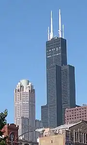
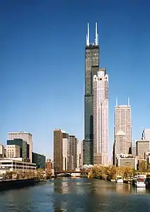
View 311 South Wacker Drive and Willis Tower
 South view taken from Chicago River
_from_the_top_of_the_Willis_Tower_29Nov2007.JPG.webp) 311 South Wacker Drive top viewed from the top floor of Willis Tower
311 South Wacker Drive top viewed from the top floor of Willis Tower.jpg.webp) 311 South Wacker Drive as viewed from the 103rd floor of the nearby Willis Tower
311 South Wacker Drive as viewed from the 103rd floor of the nearby Willis Tower
See also
References
- 1 2 3 4 5 "311 South Wacker Drive - The Skyscraper Center". Council on Tall Buildings and Urban Habitat. Archived from the original on 2013-02-02.
- ↑ "311 South Wacker - Property Information". Archived from the original on 2007-09-28. Retrieved 2007-08-13.
- ↑ Sudo, Chuck (November 28, 2016). "The Forgotten History Of Chicago Supertalls: Everything You Need To Know About 311 South Wacker". Bisnow.com. Retrieved December 20, 2018.
- ↑ emporis.com 311 South Wacker
- ↑ David Ibata, S. Wacker Skyscraper Launching chicagotribune.com October 21, 1986
- 1 2 "311 South Wacker Drive, Chicago". Archived from the original on 2007-02-06.
- ↑ Google (3 March 2016). "South Wacker Drive" (Map). Google Maps. Google. Retrieved 3 March 2016.
External links
- Official Building web site
- 311 South Wacker Drive on CTBUH Skyscraper Center
- Emporis listing